
Hey,
I could only find this post from UO about bryan island where there was any discussion about the area.
http://www.undergroundozarks.com/forum/ ... php?t=7704
Back in 2012 at least part of the island was privately owned and in 2015 it was purchased by the governement and it is now maintained by the army corp of engineers.
It is also a public use conservation area.
https://www.nwo.usace.army.mil/mrrp/site-Bryan-Island/
If you download the google earth application you can view satelite pictures for the past decade or so and see that the area was being used for farming (probaly hay).
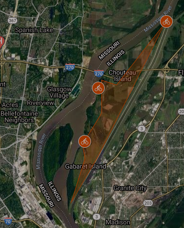
Here is some history of the island
http://www.treasurenet.com/forums/misso ... river.html
I see that most people upload directly to the UO site, but I find more modern methods more user friendly.
Here is the link to the gallery and quite a bit of information regarding the experience.
https://imgur.com/gallery/IlFRn22
I originally went out in october and didn't make it very far the terrain was difficult to pass through and the sun was setting quicker that I anticpated.
My second attempt was in december and went around the island the other idrection which was still difficult traversing unmanaged and old growth wood. It was much easier that walking through than above head reed/grass and saplings.
Bryan island exploration and visual guide.
Bryan island exploration and visual guide.
Last edited by 6brap on Tue Dec 08, 2020 2:38 pm, edited 1 time in total.


RE: Bryan island exploration and visual guide.
Nice, thanks for the info

Re: Bryan island exploration and visual guide.
I've got to go check this out..


Re: Bryan island exploration and visual guide.
Loved all those photos! Thanks for sharing your venture out there with us.
Have you ever hiked or biked on Chouteau Island?6brap wrote:

Preservation over plunder.